Unincorporated
San Mateo County
San Mateo County, situated along the Central California coastline, encompasses the major portion of the San Francisco Peninsula. Approximately 55 miles of the County’s western border is Pacific shoreline, and roughly 34 miles of the eastern border is San Francisco Bay shoreline. The County is bounded on the north by the City and County of San Francisco and on the south and southeast by Santa Cruz and Santa Clara Counties. The County’s unincorporated area includes urban pockets east of Route 280 and most of the rural area south and west of Route 280. The unincorporated County consists of approximately 309 square miles (68% of total County area), and there is wide variation in the size, location, and economic and social characteristics of the various unincorporated areas. The County’s population reached approximately 773,000 by 2020.
The topography of the County is extremely varied. Elevation ranges from sea level to 2,572 feet atop the Santa Cruz Mountains. This mountain range, running in a north-south direction, divides the County into two distinct regions, the Bayside and the Coastside. Much of the Bayside consists of mudflats, marshes, artificial fill and broad, flat alluvial plains. This level, low-lying region changes into gently rolling Bayside foothills. On the Coastside, topography ranges from gently sloping foothills abutting the western face of the Santa Cruz Mountains to broad, nearly level coastal terraces, cut by small valleys created by streamflow. Features along the shoreline range from wide, sandy beaches to rocky coves. Where wave action has eroded the coastal terraces, high, steep cliffs rise out of the ocean. Dry, mild summers and moist, cool winters characterize San Mateo County’s overall climate. Fog is prevalent on the Coastside, contributing to a productive agricultural area that grows a number of specialty crops. Bayside climates are generally warm and sunny, particularly in the summer months when hot air moving east warms the prevailing cool ocean breezes. Temperatures are strongly influenced by the Pacific Ocean and San Francisco Bay. This combination of features has resulted in a variety of microclimates throughout the County with hill and ridgetop areas, valley floors and coastal areas each experiencing different temperatures and precipitation patterns.
The vast majority of unincorporated area within the county is located in rural areas. These areas developed slowly due to limited accessibility and difficult terrain. On the Coastside there are several unincorporated coastal communities north of Half Moon Bay, including Montara, Moss Beach, El Granada, Princeton, and Miramar, which make up the urban Midcoast. In the more rural Midcoast, Southcoast, and Skyline areas, there are small unincorporated communities at La Honda, Pescadero, San Gregorio, and Kings Mountain.
San Mateo County is already experiencing the effects of climate change, including extreme heat and wind events during the summer and fall and flooding in the winter months. Other concerns are extended periods of drought, flooding, wildfire, and sea level rise.
The County is developing a Drought Resilience Plan to ensure reliability of small water systems in the county, especially during drought conditions. Learn more about the Plan here.
Local Safety and Resilience Highlights

Seismic and Geologic Hazards
San Mateo County is in a region of high seismicity because of the presence of the San Andreas Fault that bisects the county, the Hayward Fault across the bay to the east, and the San Gregorio Fault to the west. The primary seismic hazard for the county is associated with ground shaking from these three large faults. It is estimated that 38.6 percent of San Mateo County’s population resides in areas considered susceptible to ground shaking from earthquakes.
Landslides have occurred regularly throughout San Mateo County. The southwestern portion of the County has experienced repeated damage from debris flows, including the Tunitas Creek, San Gregorio, and Pescadero watersheds. Debris flows are widespread and have caused several road closures in the past, especially along Highway 1. Landslide risk is heightened following wildfire.
Inland Flooding
Inland flooding is a result of local drainage issues and heavy rain. Flooding is predominantly shallow along streams on the bayside of San Mateo County. However, flood problems are known to occur along Colma Creek; San Bruno, Crystral Springs, and Lomita Channels; Belmont Creek and Holly Street Channel; San Francisquito Creek; Montara Creek; San Vincente Creek; Denniston Creek; El Granada Creek; Woodhams, La Honda, Alpine, and San Gregorio Creeks; and Pescadero and Butano Creeks.
Inland Flooding
Flooding has been an ongoing issue for low-lying areas of Pacifica, and likely will continue to be a challenge in the future. There is a risk of flood inundation in several parts of Sharp Park Golf Course, the Rockaway Beach district, and in the Linda Mar neighborhood along San Pedro Creek.
Tsunami
A tsunami is a series of high-energy waves that radiate outward like pond ripples from an area where a generating event occurs, arriving at shorelines over an extended period. Tsunamis can be induced by earthquakes, landslides, and submarine volcanic explosions. San Mateo County has experienced six known tsunamis since 1859. A number of the County’s major roads, bridges, and utility systems are located within tsunami hazard zones, including Highway 1, State Route 92, and Highway 101.
Coastal Hazards (Sea Level Rise, Coastal Erosion, Coastal Flooding, and Groundwater Emergence)
The Pacific Ocean is the most likely source of coastal flooding in the County, although flooding from the San Francisco Bay is also a possibility during significant events. Storm surge floods typically result in coastal erosion, salinization of freshwater sources, and contamination of water supplies. These floods are also responsible for significant agricultural losses, loss of life, and damage to public and private structures and infrastructure. San Mateo County has mitigated some of its vulnerability to Bay flooding through a series of levees originally installed for salt evaporation ponds in the southeastern part of the County and for flood protection in the north and central parts of the County. However, these levees were not designed to withstand floods of magnitude greater than the 1-percent-annual-chance flood.
San Mateo County is highly vulnerable to the effects of rising sea levels. If left unmanaged, future flooding and coastal erosion could pose considerable risks to life, safety, critical facilities, the County’s natural and recreational assets, and the economy. Flooding, erosion, and sea level rise directly threaten people and property in the sea level rise hazard areas. They also have indirect effects on all communities in the County, even those on high ground, because assets and infrastructure in the sea level rise areas provide critical services and functions to communities outside these areas.
San Mateo County has more people and property value at risk from sea level rise than any other county in the state. When population projections are considered, the County is one of six counties in the nation (and the only one on the west coast) with over 100,000 people living in an area affected by 3 feet of sea level rise. Vulnerable county assets in potential hazard zones include critical facilities (police stations, hospitals, wastewater treatment plants, and schools), essential regional transportation networks and infrastructure such as the Caltrain tracks and Highway 101, State Route 1), and regional natural and recreational assets such as Pacifica State Beach and the California Coastal Trail.
In coastal areas with underlying groundwater, rising seas may enter aquifers and contribute to rising groundwater levels, or emergent groundwater. Groundwater rise will contribute to flooding in low-lying coastal communities, with impacts often occurring earlier, and farther inland, than coastal flooding from overtopping of the bay shoreline. Rising groundwater can degrade underground infrastructure, mobilize contaminants, and increase liquefaction hazards.

Dam Inundation
24 dams are in San Mateo County. Twelve of these, plus another nearby in Santa Clara County, have inundation areas that run through the county. The Lower Crystal Springs Dam is the largest dam in San Mateo County, making it a higher priority for regulation and preventative maintenance by county, state, and federal officials. Dam failure events are infrequent and usually coincide with or follow events such as earthquakes, landslides and excessive rainfall and snowmelt. Dam failure may worsen the severity of a drought by releasing water that might have been used as a potable water source. A loss of water supply could exacerbate the wildfire hazard by hindering an impacted area’s ability to fight fire.
Wildfire
Due to local topography, fuels (forest, chaparral, and grasslands vegetation) and weather conditions, San Mateo County is conducive to periodic large wildfire events. According to the CAL FIRE Fire Resource Assessment Program, areas between Shelter Cove, Moss Beach, Half Moon Bay, Sky Londa, and Crystal Springs Lake, La Honda are within high to very high fire hazard severity zones. Smoke from wildfires can negatively impact air quality and health across the county.

Extreme Heat
State agencies define extreme heat as temperatures that are hotter than 98 percent of the historical high temperatures for the area, as measured between April and October of 1961 to 1990. Days that reach this level are called extreme heat days. In San Mateo County, extreme heat on average is a daytime temperature above 85.7 degrees Fahrenheit (°F), and a warm night is nighttime low of above 56.1°F, although these numbers vary in different parts of the county. Extreme heat affects community members’ health and increases community costs and energy generation as it continues. These events can also exacerbate wildfires and impact water supplies. High demand for power for air conditioning during extreme heat can stress and overwhelm the electrical grid, leading to brownouts or power loss. Extreme heat events may degrade the quality of roadways and railways, resulting in closures and travel delays.

Severe Weather
Extreme heat affects community members’ safety and increases community costs and energy generation as it continues. These events can also exacerbate wildfires and impact water supplies. High demand for power for air conditioning during extreme heat can stress and overwhelm the electrical grid, leading to brownouts or power loss. Extreme heat events may degrade the quality of roadways and railways, resulting in closures and travel delays.

Drought
Drought is a significant decrease in water supply relative to what is needed to meet typical demand, leading to a water shortage for some activity, group, or environmental sector. While drought is a normal occurrence for Mediterranean climates such as that of San Mateo County, long and severe droughts have the potential to impact ecosystems and economic activity across the entire community. Potential drought impacts include loss of crops, costs incurred by having to drill new wells, increased costs for water straining household finances and reducing commercial profits, reduced habitat and food supply for plants and animals, and increased risk of wildfire.
In addition to these potential safety issues, fiber and cellular service is not reliable on the coast. This means that residents of coastal areas of unincorporated San Mateo County may have trouble contacting support and response services during an emergency.
Drought Resilience Plan
What is the Drought Resilience Plan?
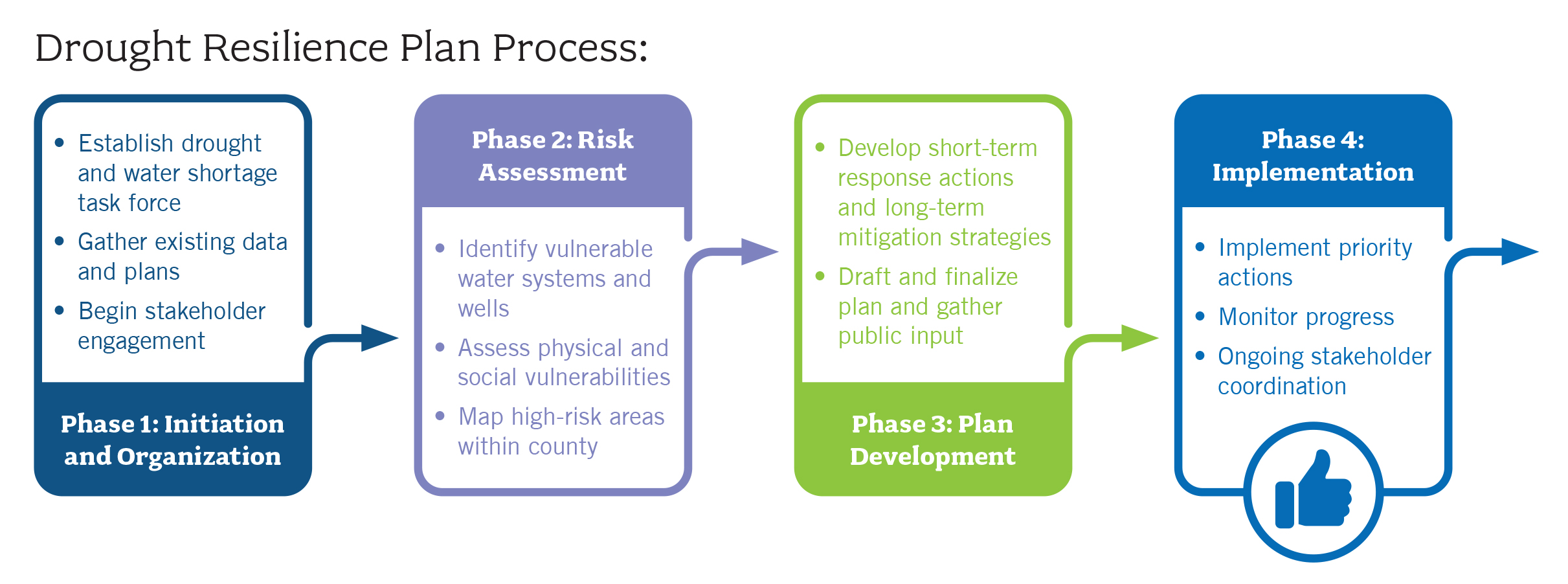
San Mateo County is developing a Drought Resilience Plan (DRP) as part of the Peninsula Resilience Planning (PREP) project. Senate Bill 552, signed by Governor Newsom in September 2021, requires counties to improve drought planning and water resilience for California’s most vulnerable water systems. The Drought Resilience Plan will serve as a roadmap for unincorporated areas of San Mateo County to continue improving water supply reliability for smaller water providers, especially during drought conditions. It focuses on reducing water shortage risks and ensuring that residents relying on State Small Water Systems (those serving 5 to 25 people) and domestic wells (private wells serving homes) have reliable access to water for basic health and safety needs. San Mateo County received grant funding from the California Department of Water Resources County Drought Resilience Planning Assistance Program to prepare this plan.
Why is this plan important?
Climate change is increasing the frequency and severity of droughts in California. While larger water systems often have multiple sources and backup plans, State Small Water Systems and domestic wells are particularly vulnerable during water shortages. These systems may lack the resources or technical capacity to respond effectively to drought conditions.
The Drought Resilience Plan will help protect our most vulnerable community members by:
- Assessing drought and water shortage risks for State Small Water Systems and domestic wells.
- Identifying short-term response actions and long-term mitigation strategies.
- Creating a framework for coordination between County departments, water suppliers of all sizes, and community stakeholders.
- Ensuring equitable access to safe drinking water during emergencies.
How Does this Connect to PREP?
The County is developing the Drought Resilience Plan as part of the broader PREP project and will be an appendix to San Mateo County’s updated Safety Element. This integration ensures a coordinated drought resilience planning effort with the County’s overall approach to climate change adaptation and hazard mitigation. The Drought Resilience Plan specifically addresses water-related hazards that could threaten public safety during drought conditions, helping to build community resilience by ensuring vulnerable populations maintain access to safe drinking water. By identifying high-risk areas and establishing emergency response protocols, the plan strengthens the County’s overall disaster preparedness and supports the broader safety goals outlined in the Safety Element.
San Mateo County Water Shortage Taskforce
As part of this effort, San Mateo County established a standing Water Shortage Task Force to help guide the development of the Drought Resilience Plan and monitor drought conditions throughout the county. The Water Shortage Taskforce is responsible for:
- Considering all perspectives in drought planning.
- Fostering relationships needed for emergency response.
- Creating shared understanding of water challenges.
- Helping protect vulnerable communities from water shortages.
- Improving overall drought resilience for the county.
The Water Shortage Taskforce is comprised of members from four distinct groups.
1. Local Government Representatives
- County of San Mateo Planning & Building Department
- County of San Mateo Public Works
- Town of Hillsborough Public Works Department
- OneShoreline
- County of San Mateo Department of Emergency Management
- Healthy San Mateo County
- County of San Mateo Office of Sustainability
- County of San Mateo Fire and Coastside Fire
- County of San Mateo Health Department
- Public Health, Policy, and Planning
- Resource Conservation District
2. Water System Representatives
- Coastside County Water District
- North Coast County Water District
- Montara Water and Sanitary District
- Palo Alto Park Mutual Water Company
3. Community Based Organizations
- Pescadero Municipal Advisory Council
- Arriba South Coast
4. State and Regional Partners
- C/CAG and Countywide Water Pollution Prevention Program
- CA Dept of Water Resources Division of Regional Assistance
Water Shortage Task Force Meetings
Meeting #1: May 19, 2025.
- Purpose: The inaugural meeting served to introduce Task Force members, provide an overview of Senate Bill 552 requirements and the Drought Resilience Plan process, and begin collecting information about local drought experiences and existing water programs. Task Force members shared their perspectives on water supply challenges observed during previous drought periods, identified vulnerable areas and populations within the county, and discussed existing drought and water conservation programs and their effectiveness.
- Meeting Notes: View notes and a summary of the meeting here.
Additional Resources
For more information about Senate Bill 552: SB 552 Primer
For more information about Drought Resilience Planning: DWR Drought Resilience Planning Guidebook
Local Links
- San Mateo County Long-Range Planning Division
- San Mateo County MJLHMP
- San Mateo County General Plan
- Emergency Operations Plan
- Local Coastal Program
- Climate Action Plan
- Green Infrastructure Plan
- Climate Ready North Fair Oaks Climate Risk Assessment
- Coyote Point Sea-Level Rise Vulnerability Assessment
- Protecting the South Coast from Sea Level Rise
- Sea Level Rise Policy for County-Owned Assets
- Sea Level Rise Implementation Plan
- Planning Policy Guidance to Protect and Enhance Bay Shoreline Areas of San Mateo County
- Sea Level Rise Adaptation Progress, Gaps, and Needs Survey
- Sea Level Rise and Overtopping Analysis for San Mateo County’s Bayshore
- San Mateo County Forest Health and Fire Resilience Public Works Plan
- County of San Mateo’s Sea Level Rise Vulnerability Assessment